
Utah
Flash Flood Warnings in effect across southern Utah
By 
Editor
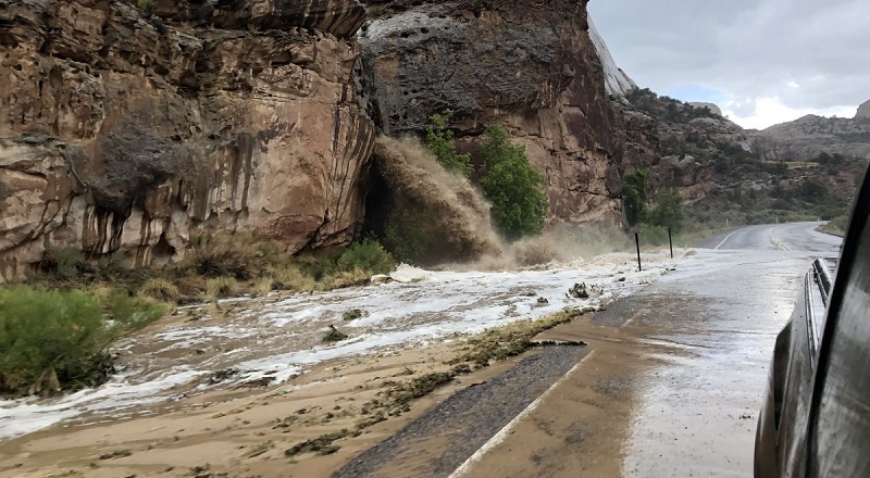
Garfield County, Utah — In several areas of southern Utah, the National Weather Service is warning the public of potential flash floods.
The NWS of Salt Lake City issued official Flash Flood Warnings starting Sunday afternoon through Sunday evening (exact times vary).
“Doppler radar indicated thunderstorms producing heavy rain across the warned area,” the NWS said in alerts for Garfield, Kane, and Wayne counties.
Other nearby areas were issued a Flood Watch, which is less severe than a Flash Flood Warning.
In the areas listed below, the NWS warned of “Life-threatening flash flooding of normally dry washes, slot canyons, slick rock areas, and small streams.”
“Turn around, don’t drown when encountering flooded roads. Most flood deaths occur in vehicles,” the warnings read. “In hilly terrain, there are hundreds of low water crossings which are potentially dangerous in heavy rain. Do not attempt to cross flooded roads. Find an alternate route. Remain alert for flooding even in locations not receiving rain. Dry washes, streams, and rivers can become raging killer currents in a matter of minutes, even from distant rainfall.”
On the border of Garfield County and Wayne County, a warning is in place until 6:15 p.m. It includes areas in and near Capitol Reef National Park, including:
• Sheets Gulch
• Cottonwood Wash
• Burro Wash
• A portion of the Notom-Bullfrog Road
Just southeast of Bryce Canyon National Park in Garfield County and Kane County, a warning is in effect until 6 p.m. for the areas of:
• Willis Creek
• Sheep Creek
• Bull Valley Gorge
• Skutumpah Road
• Portions of Grand Staircase Escalante National Monument
Another warning in Garfield County goes until 5:15 p.m. and includes:
• Zebra Slot Canyon
• Red Breaks Slot Canyon
• Harris Wash, Neon Canyon
• Bighorn Canyon
• Phipps Wash
In Kane County, a warning is in effect until 7 p.m. from the head of Last Chance Creek through where it reaches Lake Powell at Croton Canyon.
Another warning in Kane County lasts until 9:15 p.m. It includes the Paria River from central Kane County down to the Utah-Arizona border.
The NWS expects the floodwaters to reach U.S. Highway 89 between 8-9 p.m.
The risk of damage from flash floods in these areas was “considerable,” the NWS said.
Some roads in Capitol Reef National Park were already closed due to flash flooding that occurred within the past week.


Leave a Reply